Google Search

Sunday, June 9, 2013

BENCANA TANAH LONGSOR DI KERINCI

By Haryanto
10.11.4221
S1-Ti-08


1.1 Latar Belakang
Bencana tanah longsor memang sudah sering terjadi apa lagi waktu musim hujan datang. Bagi orang-orang yang tinggal di pegunungan harus berhati-hati kalau musim hujan datang. Bencana alam apa pun bentuknya memang tidak diinginkan bagi setiap orang. Sayangnya kejadian pun terus saja terjadi. Berbagai usaha tidak jarang dianggap maksimal tetapi kenyataan sering tidak terelakkan. Masih untung bagi kita yang mengagungkan Tuhan sehingga segala kehendak-Nya bisa dimengerti, meski itu berarti derita. Banyak masalah yang berkaitan dengan bencana longsor. Kehilangan dan kerusakan termasuk yang paling sering harus dialami bersama datangnya bencana itu. Harta benda dan manusia terpaksa harus direlakan, dan itu semua bukan masalah yang mudah. Dalam arti mudah difahami dan mudah diterima oleh mereka yang mengalami. Bayangkan saja harta yang dikumpulkan sedikit demi sedikit, dipelihara bertahun-tahun lenyap seketika.
1.2 Pembahasan
Enam desa di Kabupaten Kerinci, Provinsi Jambi dilaporkan terisolasi akibat bencana longsor di daerah itu sejak tiga hari terakhir. "Titik longsor menyebar di enam kecamatan. Yang terisolir (terisolasi, red.) ada enam desa," ujar Kepala Badan Penanggulangan Bencana Daerah (BPBD) Kabupaten Kerinci, Darifus, saat dihubungi di Sungaipenuh, ibu kota Kabupaten Kerinci.Enam kecamatan yang dilanda longsor itu, di antaranya Kecamatan Air Hangat Timur, Siulak Bukai, Siulak, Batang Merangin, Bukit Kerman, dan Keliling Danau. Sementara itu, enam desa yang terisolasi, yaitu Desa Sungai Kuning, Lubuk Tabun, Pasir Jaya, Pungut Mudik, Pungut Tengah, dan Pungut Hilir. "Sampai saat ini, kami masih melakukan pembersihan material longsor. Memang sedikit kewalahan karena kami kekurangan alat berat di lapangan". Darifus menjelaskan bahwa di enam desa yang terisolasi itu sedikitnya ada 3.000 kepala keluarga yang tinggal di daerah itu. Sebagian besar, warganya adalah petani sehingga sejak tiga hari ini petani kesulitan menjual hasil pertaniannya. Lebih lanjut dia mengatakan, meski terisolasi, enam desa tersebut diakuinya belum membutuhkan bantuan logistik karena masih mencukupi. "Sampai saat ini, petugas kami siagakan di titik-titik lokasi dan rawan longsor, mengingat hujan masih terjadi dan dikhawatirkan terjadi longsor susulan”. Berdasarkan data sementara BPBD Kerinci, titik longsor di enam kecamatan itu sebanyak 17 titik. Sementara itu, titik longsor paling banyak ada di Kecamatan Air Hangat Timur dan Siulak Bukai yang mencapai 10 titik. Atas bencana itu, Darifus mengharapkan bantuan dari Pemerintah Provinsi Jambi, mengingat hanya ada satu alat berat yang ada untuk membersihkan material longsor di belasan titik lokasi. "Apalagi jarak antara satu kecamatan dan kecamatan lainnya jauh. Ini menjadikan penanganannya lambat karena kekurangan alat berat”. Kabupaten Kerinci merupakan salah satu daerah pegunungan di Provinsi Jambi. Kondisi itu menyebabkan daerah ini menjadi daerah paling rawan bencana provinsi itui. Hampir setiap musim hujan tiba, kerap terjadi longsor. Belum lama ini, jalur lintas Kota Jambi menuju Sungai Penuh, Kerinci sempat terputus hingga 10 jam lebih akibat longsor di Kecamatan Muara Imat.


1.3 Faktor Penyebab Tanah Longsor
1 Hujan
Ancaman tanah longsor biasanya dimulai pada bulan November seiring meningkatnya intensitas hujan. Musim kering yang panjang akan menyebabkan terjadinya penguapan air di permukaan tanah dalam jumlah besar. Muncul-lah pori-pori atau rongga tanah, kemudian terjadi retakan dan rekahan tanah di permukaan. Pada saat hujan, air akan menyusup ke bagian yang retak. Tanah pun dengan cepat mengembang kembali. Pada awal musim hujan, kandungan air pada tanah menjadi jenuh dalam waktu singkat. Hujan lebat pada awal musim dapat menimbulkan longsor karena melalui tanah yang merekah itulah, air akan masuk dan terakumulasi di bagian dasar lereng, sehingga menimbulkan gerakan lateral. Apabila ada pepohonan di permukaan, pelongsoran dapat dicegah karena air akan diserap oleh tumbuhan. Akar tumbuhan juga berfungsi sebagai pengikat tanah.
2 Lereng terjal
Lereng atau tebing yang terjal akan memperbesar gaya pendorong. Lereng yang terjal terbentuk karena pengikisan air sungai, mata air, air laut, dan angin. Kebanyakan sudut lereng yang menyebabkan longsor adalah 180 apabila ujung lerengnya terjal dan bidang longsorannya mendatar.
3 Tanah yang kurang padat dan tebal
Jenis tanah yang kurang padat adalah tanah lempung atau tanah liat dengan ketebalan lebih dari 2,5 meter dan sudut lereng > 220. Tanah jenis ini memiliki potensi untuk terjadinya tanah longsor, terutama bila terjadi hujan. Selain itu, jenis tanah ini sangat rentan terhadap pergerakan tanah karena menjadi lembek jika terkena air dan pecah jika udara terlalu panas.
4 Batuan yang kurang kuat
Pada umumnya, batuan endapan gunungapi dan batuan sedimen berukuran pasir dan campuran antara kerikil, pasir, dan lempung kurang kuat. Batuan tersebut akan mudah menjadi tanah jika mengalami proses pelapukan dan umumnya rentan terhadap tanah longsor apabila terdapat pada lereng yang terjal.
5 Jenis tata lahan
Tanah longsor banyak terjadi di daerah tata lahan persawahan, perladangan, dan adanya genangan air di lereng yang terjal. Pada lahan persawahan akarnya kurang kuat untuk mengikat butir tanah dan membuat tanah menjadi lembek dan jenuh dengan air sehingga mudah terjadi longsor. Sedangkan untuk daerah perladangan penyebabnya adalah karena akar pohonnya tidak dapat menembus bidang longsoran yang dalam dan umumnya terjadi di daerah longsoran lama.


6 Adanya beban tambahan
Adanya beban tambahan seperti beban bangunan pada lereng, dan kendaraan akan memperbesar gaya pendorong terjadinya longsor, terutama di sekitar tikungan jalan pada daerah lembah. Akibatnya adalah sering terjadinya penurunan tanah dan retakan yang arahnya ke arah lembah.
7 Pengikisan/erosi
Pengikisan banyak dilakukan oleh air sungai ke arah tebing. Selain itu akibat penggundulan hutan di sekitar tikungan sungai, tebing akan menjadi terjal.
8 Penggundulan hutan
Tanah longsor umumnya banyak terjadi di daerah yang relatif gundul dimana pengikatan air tanah sangat kurang.
1.4 Cara mengatasi/mencegah tanah longsor
1.      Menjaga kelestarian hutan.
2.      Membuat dreynase.
3.      Menutup retakan dengan tanah lempung.
4.      Tidak menebang hutan di lereng.

5.      Tidak membuat lahan pertanian baru atau kolam

Wednesday, February 6, 2013

Bled Lake are amazing places in Slovenia


Lake Bled is the ideal place to explore Slovenia's natural and cultural heritage rich in rural areas and the activities offered. Lake Bled is very enchanting and mysterious ancient cliffs above the castle is transformed into a winter wonderland when decorated by a covering of snow with the scent of roasted chestnuts drifting through the trees if you want to look at Bled in style, love train ride around the Lake. Bled surrounded by mountains and with a fairytale Castle perched atop reefs facing a 17th-century Church on an island. Every visitor is fascinated by the fantastic variety of Bled views and alpine lakes. Bled Island, for centuries the symbol of the region. Clifftop castles imposing broods Lake and offers a stunning view of Lake Bled, the surrounding area and the highest peaks in Slovenia. The resort is ideal for active or relaxing winter holiday in Slovenia, offers many opportunities for those who want to test their skills on the ski slopes nearby, try one of the many winter activities available, or be pampered at the health center, with a selection of massage treatments, jacuzzi, sauna and steam room.


Tuesday, January 15, 2013

Mono Lake is a beautiful place in California


The mid-20th century, to satisfy the needs of Los Angeles water they have to fetch water from local streams and rivers including the Owens River that feed Mono. As a result, the lake level dramatically falling by 15 meters find the numbers calciferous tuff from the water. Only in 1994, a program devoted to the safety of the unique Lake was adopted. After this the surface of the Lake began to increase. After threatened when water packed redirected towards the Valley of Los Angeles it lost half the volume in 40 years before agreement was reached to keep it. Mono Lake today is 7 vertical feet lower than the targeted level, and could be well into 2010 before it reaches the depth of it. Mono Lake is the largest natural lake entirely within the State of California, and unique. Mono Lake Lake is located at an elevation of 1945 m, its area is 150 square kilometers and an average depth of 43 meters.


Friday, January 11, 2013

Red Beach a beautiful place in China


Red Beach is a beautiful area and a protected natural reserve of 26 kilometres long and almost a mile wide at the Liaohe River near the mouth of the River. Red Beach about 30 kilometers southwest of the city of Panjin in China. The beach gets its name from its appearance, which is caused by a type of seaweed that is grown on the surface of the water. This is a key habitat for migratory birds on the route of the East Asia-Australia. Endless expanse that is unique in the reed marshes the second largest in the world, Red-crowned crane, black-beaked gulls and terns and the former seal, see and the public, is part of the wetland ecosystem rich in colorful colors. The grass began to grow during April or may remain green throughout the summer. In the fall, weeds still pink and looks as though it is covered by a red carpet which creates limitless views Red Beach are rare. Covering an area of nearly 600,000 hectares, including Liaohe River Delta swamp Panjin and Yingkou city, in Liaoning province, where the Hekou nature reserve Shuangtai has been set.


A beautiful Kyoto in Japan


Kyoto is Japan's traditional culture and shed the stage where a lot of the history of Japan played and find your imagination. The lodges a poet hidden amidst the bamboo groves, arcade vermilion Temple Gate, geisha disappeared into the door of the temple is a traditional restaurant, gold floating above the calm waters. Indeed, it is fair to say that Kyoto ranked with Paris, London and Rome as one of the cities that everyone should see at least once in their lives. Kyoto Kaiseki cuisine is haute, an elaborate multicourse meal that comes from around 500 years ago as an accompaniment to the tea ceremony. Two and a half years ago, the city enacted a landmark law intended to protect the city's heritage district, which contaminates in recent decades by the tower blocks of concrete and other forces of modernization. Indeed, most of the sites that make up the popular image of Japan from Kyoto. With 17 World Heritage sites, Buddhist temples in more than 1600, and more than 400 Shinto Shrines, and also one of the most culturally rich cities in the world.


Wednesday, January 9, 2013

Menorca Island Tourism in Spain


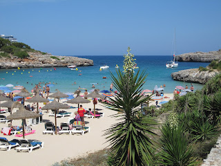
Menorca Island was one of the three Balearic Islands located off the coast of Spain in the Mediterranean Sea and the quietest of the Balearic Islands. The Unesco biosphere reserve designation, released in 1993 for the flora and fauna that thrive in Menorca Island, forests, canyons, wetlands, salt marshes and hillsides. Menorca Island has a typical Mediterranean climate with long hot summers, mild winter and shorter. Menorca Island look about 300 days of sunshine per year. Summer is the best time to visit. Menorca is the second largest Island and the northern tip of Menorca, Balearic Islands also has a wet and usually a few degrees cooler than on other islands. In 2004, Unesco protective broaden its reach, including a broad definition in the scattered islands prehistoric site, effectively preventing the construction of high-rise condominiums and hotels. In contrast, rural Hotel called agrotourismos is the choice hotel outside the city, and approximately 120 separates the beaches of Majorca and Ibiza but is mostly unsullied by the construction.


Lake Baikal stunning place in Rusia


Lake Baikal is a freshwater lake that is one of the oldest on Earth 25 million years, as well as the deepest continental body of water, has a maximum depth of 5,315 feet (1,620 meters). Lake Baikal is located in the southern part of the Buryatia Republic in Eastern Siberia and Irkutsk oblast, Russia. Baikal is surrounded by mountains, some of which are as high as more than 6,600 feet (2,000 meters) above the surface of the Lake. the length of the Lake Baikal 395 miles (636 km) wide and averages 30 miles (48 km). Baikal contains some 45 of the island. ; the earthquake occurred in 1862 and spent approximately 77 square miles (200 square miles) in the North of the Selenga delta, creating a new Gulf known as the Gulf of Baikal Proval. It is also the largest freshwater lake in the world by volume, which contains about one-fifth of fresh water on the Earth's surface, some 5,500 cubic miles (23,000 cubic km). Flowing into Lake Baikal is more than 330 rivers and streams, the largest include the Selenga, Barguzin, upper Angara (Verkhnyaya), Chikoy, and Uda. It has steep slopes on the West Coast and the slopes gently to the East.


Twitter Delicious Facebook Digg Stumbleupon Favorites More

 
Design by Free WordPress Themes | Bloggerized by Lasantha - Premium Blogger Themes | Blogger Templates